City of Benicia
The plan has been a long time coming, Michael Dotson, director of the Parks and Community Services Department, wrote in a report to the Council. It stems from an initiative in 2004 to establish a waterfront park on city-owned land south of B Street between First Street and the harbormaster’s office.
The site extends to the water’s edge, and only excludes the Southern Pacific Depot, which houses Benicia Main Street.
It’s also the latest in a series of developments along the waterfront, Dotson wrote.
The city initially received approval in June 1977 from the Bay Conservation and Development Commission (BCDC) to make changes along the waterfront area in the peninsula area between Fifth and First streets.
That included the construction of the city marina, fishing pier, public boardwalks, tidal marshes, public pedestrian and bicycle ways, parking, overlooks and commercial and residential development.
That permit has been amended 34 times since it was issued, and many of those projects have been finished.
In 1991, an urban waterfront restoration plan was seen as a way to make better use of the city’s downtown area waterfront through preservation of open space and historical characteristics, increased access to the waterfront and introduction of new activities and commerce to the area.
That led to construction of the First Street Promenade and Peninsula Pier, Dotson wrote.
After the 2004 Waterfront Park Initiative, a group of citizens organized the Waterfront Park Committee in 2008 to develop concepts for the waterfront that built on the 1997 Parks, Trails and Open Space Master Plan.
“The group became a subcommittee of the Parks, Recreation and Cemetery Commission in March 2009,” Dotson wrote.
That same year, the City Council approved a concept plan for a plaza south of the depot, and that plan has been incorporated into the new master plan, Dotson wrote.
Also in 2009, the city applied for a Coastal Conservancy grant that would develop a site master plan that would incorporate the subcommittee’s vision, Dotson wrote. The Coastal Conservancy approved a grant award in September 2011.
The next year, the Council contracted with PlaceWorks, formerly Planning Center/DC&E, as the lead on an interdisciplinary consultant team for the project, and told staff to form a community advisory committee with members from 11 city advisory panels as well as community organizations.
Multiple meetings provided comments and review of the project’s progress, and by Nov. 19, 2013, the Council told staff to go ahead and draft the master plan.
The U.S. Army Corps of Engineers examined the site and verified the wetland delineation last July, which led to modification of some of the draft’s preferred alternatives to accommodate limits on filling and mitigation requirements.
The Corps also advised the city about certain issues that might interfere with its obtaining permits, and after meetings with BCDC, the Regional Water Quality Control Board and California Department of Fish and Wildlife, more changes were made.
These included limiting fill to a half-acre or less and providing mitigation wetlands at a ratio of two to one, and possibly higher in the Coastal Salt Marsh, Dotson wrote.
“The majority of the Seasonal Wetland will need to be retained as-is, and additional mitigation in the Coastal Salt Marsh is now proposed for the ‘panhandle’ of the green and some of the area in the northeast corner of the project area that had been proposed as bioswale (landscaped drainage) in the Nov. 5, 2013, Draft Preferred Alternative,” he wrote.
The BCDC Design Review Board examined the draft preferred alternative last February, Dotson wrote.
“The DRB was broadly supportive of the conceptual site plan,” he wrote, though it commented about whether proposed public access would be adequate and whether filling would be appropriate or needed for public access and appearance.
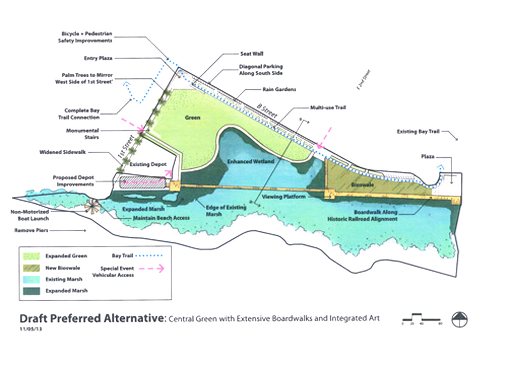
The draft master plan has an entry plaza at the center of First and B streets with seat walls and public art, an expanded raised green, a secondary plaza at the east end of the site that has seating and public art, a depot plaza based on the 2009 Depot Site Plan, Bay Trail alignment within the park parallel to B Street, a perimeter trail around the First Street Green and a boardwalk that follows the historic railroad area with viewing platforms that would overlook the wetlands and the Carquinez Strait.
Also part of the plan are improved beach access at the southwest edge of First Street north of the pier, widened sidewalks and new palm trees on the east side of First Street that would mirror the promenade on the west side of the street, stormwater rain gardens between B Street and the Bay Trail, parking improvements, removal of First Street beach pilings and informative signs.
Although a non-motorized boat launch was discussed, it wasn’t included at the First Street beach or on the west side of First Street because the tide isn’t often high enough for the designation, Dotson wrote.
But the piling removal and beach cleanup would improve safety for the users of such small boats, he explained.
Dotson said more study is needed on stormwater management and sea level rise improvements on B Street. The master plan proposes a limited resolution of those matters, he wrote, and the current climate adaptation project also is examining conditions in that area and the city’s entire coastline.
“However, a separate engineering study is needed to properly address flooding on B and East Second streets,” he wrote. Raising the elevation of a significant part of the green might reduce the scope and costs of the solution, and staff recommended addressing those problems concurrently.
Improved pedestrian and bicycle circulation on all sides of the intersection of First and B streets also needs to be addressed, he wrote.
Getting the plan approved is just one step in getting the waterfront park built, Dotson wrote. It will take money the city currently doesn’t have for the construction work; however, “A number of suitable funding sources have been identified,” he wrote.
He listed such agencies as the California Coastal Conservancy, Strategic Growth Council, Association of Bay Area Governments, San Francisco Bay Trail Project, Department of Water Resources, the Wildlife Conservation Board and the California Active Transportation Programs that include Caltrans, Metropolitan Transportation Commission and the Solano Transportation Authority.
The Council will meet at 7 p.m. Tuesday in the Council Chamber of City Hall, 250 East L St.


Sharing is caring!

Keep up the good work on the Benicia waterfront improvements. They are an asset to all of us AND the region as well. How many towns have such a gorgeous waterfront? Jack London would agree.
Peter Bray, Benicia, CA
No more palm trees. Not Native to Benicia
And where’s the money supposed to come from for this crap? We can’t even get new bocce courts built but we have money to mess with nature? Seems dumb to me. Scrap the plan!!