■ Weather front brings total winter precipitation to more than 7 inches

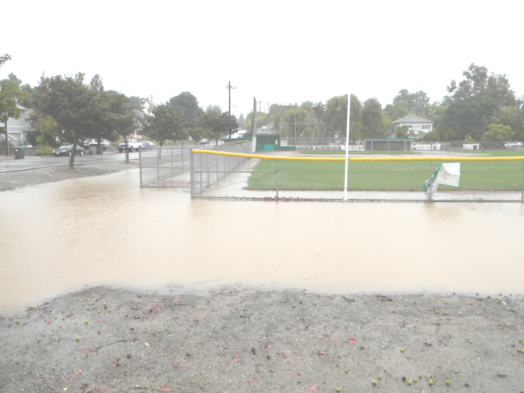
RAIN COLLECTED into a pond Thursday at the ball fields at Third and H streets.
Donna Beth Weilenman/Staff
Benicians were prepared for the storm, said Gene Pedrotti, who owns Pedrotti Ace Hardware in Southampton Shopping Center.
“We couldn’t keep the batteries on the shelves,” Pedrotti said. He said other storm preparation products also had sold quickly. “We are restocking shelves as fast as we can.”
By early afternoon Fire Station 11, 150 Military West, had reported 1.16 inches of rain, for a season total of 7.06 inches. The high was 64 degrees at 4:03 a.m. and the low was 56 degrees at 10:51 a.m. Thursday.
Northwest winds had gusts up to 22 mph.
At Fire Station 12, 601 Hastings Drive, rainfall measured 1.31 inches for a season total of 7.17 inches. West winds gusted up to 31 mph. Thursday’s high, at 3:57 a.m., was 64, and the low, at 10:47 a.m., was 55 degrees.
The Water Treatment Plant, 100 Water Way, recorded 0.95 inch Thursday, for a seasonal total of 5.53 inches. South southeast winds had gusts up to 30 mph. High at 3:58 a.m. Thursday was 64.6 degrees, and the low, at 10:59 a.m., was 55.3 degrees.
“Benicia fared better than many Bay Area communities during the storm,” City Manager Brad Kilger said Thursday afternoon. “The storm drainage system was able to handle the rainfall runoff, and there are no reports of property damage.
“This morning, the Public Works Department staff responded to a total of 66 separate storm related activities. East Second Street is closed between D and E streets as it is a low-elevation area near the Carquinez Strait, and signs are in place detouring traffic to First Street. The east end of B Street is flooded and there has been minor street flooding in several parts of the city.”
Kilger credited Public Works and Caltrans workers for their storm preparations, including pruning trees and cleaning drain pipes.
Pacific coastal areas received even more rain, with 7 inches reported north of San Francisco and more than 4 inches in both Santa Rosa and Novato. The rains produced some localized flooding, and early reports suggested enough snow may have fallen in the Sierras to raise the snowpack level. Before the storm, the snowpack was 35 percent of the amount that should be there by this time of year. Some forecasters said that could change to 75 percent or more by Sunday.
Pacific Gas and Electric received so many reports of power outages throughout the San Francisco Bay Area that telephone circuits became overloaded. Before midday Thursday, thousands of customers had lost power to downed lines and a blown San Francisco substation.
Among those outages were those reported in Dixon, where Dixon Avenue was closed from the city limits to Robben Road while PG&E repaired a downed power line. Pedrick Road, also in Dixon, from Midway Road to Vaughn Road, was closed for power line repair, too, according to Solano County’s Emergency Information reports.
California Highway Patrol said several trees had fallen on major road arteries in the East Bay and South Bay, and flooding on North California Highway 101 in Petaluma led to a CHP alert to motorists.
Vallejo Ferry trips to San Francisco were paused after some riders experienced a rough crossing earlier Thursday, until normal operations resumed shortly before 11 a.m., when the agency confirmed it could dock safety at the Ferry Building.
Alameda-Oakland Ferry service also was interrupted, and east- and westbound Harbor Bay ferry service and South San Francisco ferries were canceled Thursday because of rough waters.
Weather concerns also forced San Francisco cable cars out of service. Several Bay Area Rapid Transit stations were affected, and one lane of the Golden Gate Bridge was turned into a buffer zone to compensate for blustery winds.
The National Weather Service said the storm’s peak gusts reached 147 mph near Lake Tahoe around 9 a.m. Thursday, and other mountain areas experienced hurricane-level sustained winds. The lake itself was experiencing 7-foot waves, the Weather Service said.
Unlike in some Bay Area cities, all Benicia public schools were open Thursday, and no school experienced any weather-related problems, according to reports from Benicia Unified School District.
But San Francisco, Oakland and Berkeley unified school districts, as well as City College of San Francisco, San Francisco State University and the College of Marin, were closed.
A high surf advisory remains in effect until 10 a.m. Friday, and surfing sites reported 20-foot waves, though conditions were called poor for attempting to ride the powerful waves. Health officials advised surfers against contact with water for 72 hours because of increased bacteria levels from drainpipes, harbors and rivers.
Showers are likely Friday, with a possible thunderstorm between 10 a.m. and 4 p.m.
Additional thunderstorms may develop later in the afternoon or early evening. But rainfall is expected to be less than a tenth of an inch, according to the National Weather Service.
Rain chances drop from 60 to 40 percent overnight, and some areas may experience fog late Friday or early Saturday.


Leave a Reply