Monticello Dam, which created Lake Berryessa in 1957, holds a capacity of 1.602 million acre-feet of water.
www.scwa2.com
But what are they?
The California State Water Project, often called by the acronym SWP, was established in 1960, and is the largest publicly built and operated water and power development and conveyance system in the world, delivering an average of 2.4 million acre-feet each year. It’s entitled to move nearly twice that, though environmental concerns about the Sacramento-San Joaquin River Delta also restrict water delivery.
A century before the SWP was built, miners built flumes and ditches to divert water so they could obtain gold. As the success at gold mining dropped, the “Forty-niners” turned to farming, and others moved to cities that built local water systems.
Concerns about California water conveyance date back to President Ulysses Grant, who commissioned an investigation in 1873 to look at the state’s needs. Five years later, the state commissioned its own study.
The two reports concluded that the waters of the Central Valley should be developed. Among the developments recommended in the state study was construction of 200 stream gauges.
Lt. Robert B. Marshall of the U.S. Geological Survey proposed a statewide water project that would move water from the Sacramento River to the San Joaquin Valley, over the Tehachapi Mountains and into Southern California.
The State Water Project might have been built earlier, but the Great Depression intervened. The plan was ready and the state Legislature authorized construction, but in the middle of the Depression, revenue bonds couldn’t be marketed.
Instead, the federal government built the Central Valley Project to provide water to parts of the Central Valley and the Bay Area.
After World War II, people began moving to California, building up its metropolitan areas, particularly San Francisco and Los Angeles. Groundwater basins were being depleted and cities realized they didn’t have enough water to meet residents’ needs.
New studies were made, and proposals were offered for a dam, reservoir and power plant near Oroville; a peripheral canal and an electric power transmission system; an aqueduct from the Delta to Santa Clara and Alameda counties; and another aqueduct from the Delta to the San Joaquin Valley and Southern California.
Further revisions added the San Luis Reservoir and both North Bay and South Bay aqueducts.
The scope of the project intimidated some, and it pitted residents from Northern California against those in Southern California. Those in the north wanted assurances that waterways would be protected, and those on Delta islands urged rehabilitation of levees.
Meanwhile, those in the south wanted guarantees that northern concerns wouldn’t lead to their water supply being cut off.
While the communities disputed, San Joaquin Valley farmers supported the project because it didn’t limit irrigation the way the federal Central Valley Project did. Siding with them were labor organizations that saw the construction project as a source of jobs.
Negotiations through the years resulted in the Delta Protection Act of 1959 and multiple other laws that promised northern counties that water would be available for future projects, and southern counties that they wouldn’t lose access to water.
Consultants spurred further modifications after studying both the feasibility of the project and financing aspects.
The Burns-Porter Act, also called the California Water Resources Development Bond Act and Proposition One, was put on the November 1960 ballot, and despite San Francisco opposition it passed by a slim margin. The bond issues financed most of the SWP’s construction.
Repayment of those bonds is by project beneficiaries, rather than taxpayers, according to the state Department of Water Resources description of the SWP.
The project is supervised by the Department of Water Resources (DWS), and it provides drinking water for more than 23 million people.
The SWP also generates an annual average of 6,500 gigawatt hours (GWh) of hydroelectricity. Ironically, it’s also the largest single consumer of power — its net use is 5,200 GWh.
Normally, it is the largest supplier of Benicia water, providing the city with about 85 percent of what it uses.
The SWP collects water from Northern California rivers and sends it south through aqueducts, pumping stations and power plants, according to information provided by the DWS.
About 30 percent irrigates 750,000 acres of Central Valley farms, sent there through conveyances SWP shares with the federal Central Valley Project.
The rest goes to urban customers, from San Francisco to Southern California.
Water is transported through pumps, plants and aqueducts, including the highest single water lift in the world that takes the liquid 200 feet over the Tehachapi Mountains.
Benicia is one of 29 contractors that reserve the right to SWP water. The city contracts and pays for 17,000 acre-feet under its agreement with the state, and usually gets 10,000 acre-feet of that allocation.
But this year the city and other contractors were told that no one would get any SWP water. Later, state officials said contractors may get 5 percent starting in September.
To make up that lack, Benicia’s City Council authorized spending up to $900,000 for water purchases, and began looking at its other available water sources.
In contrast to the SWP, the Solano Project is a federal project. It stores water in Lake Berryessa until it’s delivered to regional users.
As agriculture developed in Solano County, the use of groundwater increased substantially, according to information provided by the county.
To deal with growing worries about water, the Solano Project first was conceived in the 1940s to provide a surface water supply to offset the groundwater overdrafts that were persisting in several parts of the county.
The Solano Project was authorized Nov. 11, 1948 under the Reclamation Project Act of 1939.
Originally, the project was conceived as including Napa and Yolo counties. Most of the project is in Solano County, but Lake Berryessa is in Napa County, and Monticello Dam, in front of the reservoir, is in Yolo County.
But those two counties declined to participate, and the Solano Project was modified to be able to supply municipal and industrial water needs and irrigate about 96,000 acres of land in this county.
However, planners at the time didn’t realize that Solano County’s urban population would increase dramatically.
The project needed congressional authorization before the $38 million construction could start.
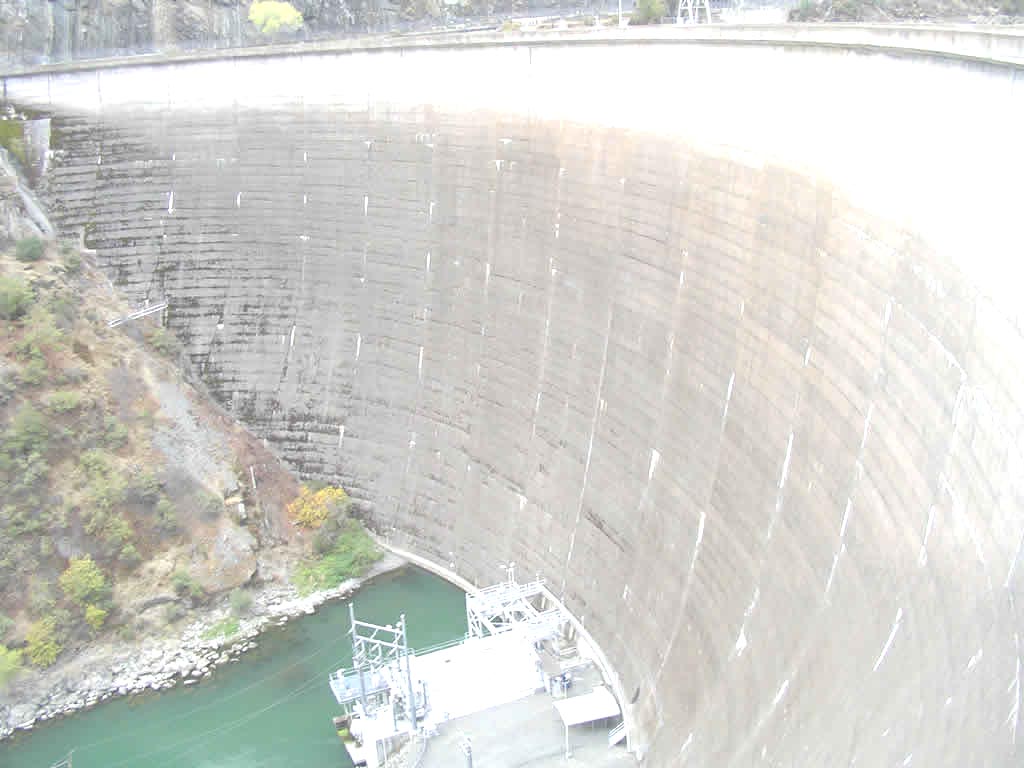
The 304-foot high Monticello Dam was built from 1953 to 1957 near where Putah Creek crosses the eastern Napa County line.
The dam regulates water on the lower reaches of Putah Creek and has a capacity to hold 1,602 million acre-feet of water in Lake Berryessa.
With 165 miles of shoreline, Lake Berryessa is more than just a water container. It also is a popular water recreation area, with year-round visitor and park ranger programs, houseboat rentals, marinas, camping, swimming and fishing for a variety of species, from rainbow trout to bass and bluegill.
The Monticello Dam power plant has three generators and is owned and operated by the Solano Irrigation District.
The Putah Diversion Dam, on Putah Creek, was finished in 1957 and diverts water to the Putah South Canal, which ends in Cordelia.
Besides providing irrigation water, the canal carries water to Vacaville, Fairfield, Suisun and Vallejo.
The Terminal Dam and reservoir at the end of the Putah South Canal is a forebay, from which water is sent to Vallejo, and is a carryover supply should flow be interrupted.
The Green Valley Conduit is a high-pressure pipeline from Putah South Canal to Green Valley. The pipelines and its smaller conduits carry water to farms.
The system also has a $15 million distribution drainage system built by the Solano Irrigation District.


Sharing is caring!